









Nasa’s NISAR satellite has captured an unusual view of Antarctica, revealing a frozen landscape that appears to form the shape of a hummingbird from space. The striking pattern is not a feature simply carved by nature, but the result of a mountain interrupting the slow movement of glacier ice around it. Using advanced radar technology, NISAR was able to map details hidden within the icy terrain that ordinary satellite images cannot easily detect. TThe colourful image shows deep cracks, shifting ice patterns and the influence of a rocky peak beneath the frozen surface. Behind the eye-catching shape is a closer look at how Antarctica’s glaciers move and respond to the landscape beneath them.
Nasa radar captures the mountain behind Antarctica’s ‘hummingbird’ pattern
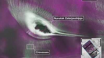
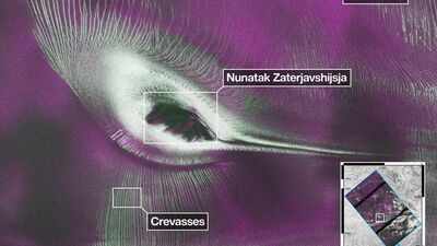
The image centres on Nunatak Zaterjavshijsja, a rocky mountaintop in East Antarctica that rises above an otherwise continuous stream of glacier ice. While the surrounding ice gradually flows towards the ocean, the exposed peak remains fixed in place, interrupting that movement much like a boulder in a fast-moving river.The disruption produces stresses all through the ice sheet. Rather than being a smooth sheet, the ice starts breaking into pieces due to having to bend and stretch around the mountain. The cracks form on the surface in a manner that shows how the glacier reacts to the disruption.This radar map created from the data gathered in August 2025 converts the physical changes to colourful designs which appear like a hummingbird with outspread wings.
Inside the radar signals that turned Antarctic ice into a colourful map
Unlike optical satellites that record reflected sunlight, NISAR studies Earth by transmitting microwave radar pulses and analysing the signals that return. This allows scientists to examine landscapes regardless of cloud cover or the absence of daylight, an important advantage in Antarctica.For this observation, the spacecraft’s L-band radar transmitted horizontally polarised signals towards the surface. The returning waves carried different orientations depending on how they interacted with the ice.Areas shown in magenta indicate places where the radar signal is reflected from relatively smooth surfaces. Those are generally sections of ice that have fewer irregularities.Green highlights radar waves that scattered in multiple directions or partly penetrated the ice before returning. Such behaviour is commonly associated with rough terrain, including the walls and complex surfaces inside crevasses. Where both types of scattering are equally strong, the image appears white, suggesting a combination of smoother and more irregular structures within the same area.
How Nasa and Isro combined two radar systems in one spacecraft
NISAR is a joint Earth observation mission developed by Nasa and the Indian Space Research Organisation (Isro). It combines two radar systems operating at different wavelengths, making it the first satellite designed to carry both L-band and S-band synthetic aperture radar instruments on a single spacecraft.Nasa’s Jet Propulsion Laboratory, managed by Caltech, led the United States’ contribution, supplying the L-band radar system along with the large antenna reflector. ISRO developed the spacecraft bus and the S-band radar instrument.